Hours, minutes, and seconds are defined identically in both solar and sidereal measure
A solar day is the amount of time that passes for the sun to cross the same celestial meridian
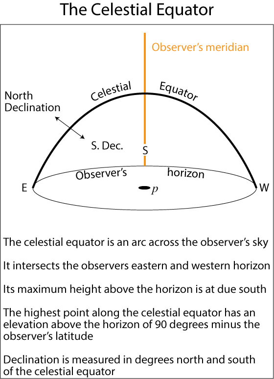
For any location on earth, the observer's meridian is the curved line connecting the point on the horizon due south of the observer's location with the zenith (the point directly overhead)
This line is often simply referred to as the meridian
In the following illustration, the observer is at p, facing south
Local noon is the time for an observer at p when she sees the center of the sun crossing the meridian
So, if you were to pick an outdoors location and observed when the sun crossed the meridian, one solar day (exactly 24 hours) would pass before it did so again.
One solar day corresponds to the rotation of the earth by 360.986°
perhaps not what you were expecting
As the earth revolves around the sun, it has to rotate more than 360° for the observer's meridian to realign with the sun
An extra 3 minutes and 55.909 are required for the earth to rotate that 'extra' .986 degrees
And as it's doing so, it also continues traveling in its orbit around the sun
Sidereal time
A sidereal clock measures ‘star time’
Compared to the definition for a solar day, a sidereal day is much easier to understand geometrically
A sidereal day is the time that passes from the moment a star (other than the sun) crosses an earth meridian to the moment it crosses the same meridian again
Unlike the sun, any other star in the sky is so far away that its light always appears to come from the same direction in the sky
One sidereal day is approximately 23 hours, 56 minutes, 4.091 seconds
That's how long it takes the earth to rotate exactly 360.0°
A sidereal day is shorter than a solar day because it doesn't need that extra 3 minutes and 55.909 seconds of rotation to follow the relatively nearby sun
Remember that hours, minutes, and seconds are defined exactly the same in both solar and sidereal time—it's only the definition of a day that's different
Seeing the difference between solar and sidereal time
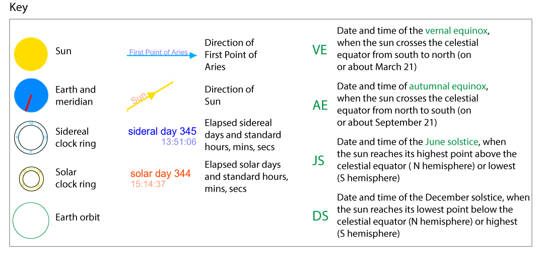
I've created the following app, Solar and Sidereal Time, to demo how each system records time as the earth revolves about the sun
In the app,
Our viewpoint lies above the north poles of the earth and the sun
As seen from this viewpoint, the earth moves counter-clockwise about the sun, and rotates counterclockwise (west to east) about its polar axis
If you viewed the system from above the south poles, the rotation motions would appear clockwise
The blue line represents the direction of light from a star in the direction of the First Point of Aries (the point in the sky where the sun crosses the celestial equator on or near March 21)
The yellow line represents the direction of light from the sun,
VE, JS, AE, and DS represent the vernal (March) equinox, June solstice, autumnal (September) equinox, and December solstice respectively
Please note: This app records elapsed time and defines a year as 365 solar days. The first clock tic of solar or sidereal time is day 0, time 00:00:00. The last tic for the year is solar day 364, 23:59:59 and sidereal day 365, 23:55:06
On the next clock tic, both times roll over to 0.
Unlike this app, the first day of the standard Gregorian calendar is day 1 and the last, non-leap year day is day 365
Both the year in this app and the Gregorian calendar count 365, 24 hour solar days
As the earth (the blue disk with the red meridian) rotates, the app counts another elapsed solar day when the red meridian crosses the solar 0-hour line (on the yellow ring with orange numbers)
Another elapsed sidereal day is counted when the red meridian crosses the sidereal 0-hour line
On a desktop browser, you can click, hold, and dragthe blue disk (the earth) around the circle to see the difference between solar and sidereal elapsed time at different points in the earth's orbit around the sun
You can also drag with your finger on touch screen devices
The slider at the top controls the animation speed
You can stop and restart the animation using the Go/Stop button
You can advance the clock using the +Sec, +Min, +Hour and +Sol day and +Sid day buttons
Clicking the Reset Clock button sets the earth's position over the date of the vernal equinox and sets all times to 0
As mentioned above, a solar day is 3 minutes and 55.909 seconds longer than a sidereal day
The extra rotation in that time (.986°), multiplied by 365 days, equals approximately 24 hours of 'extra' rotation
That's why a solar year contains approximately one more sidereal day than it does solar days
A year takes 365.2422 solar days or 366.2284 sidereal days to complete
GPS satellites make 1 complete orbit of the earth in 1/2 sidereal day (approximately 11 h 58m 2s per orbit)
This is 1 min, 58 sec short of a solar day
Multiplying the approximate difference by 2 and rounding gives 3 min, 56 seconds per day (essentially 3 min, 55.909 seconds, the difference between a full solar and sidereal day)
Therefore, each satellite's second orbit of the day appears to set on the observer's horizon 3 minutes and 55.909 seconds earlier than that of the previous solar day
More facts on sidereal time:
A solar clock and a sidereal clock read the same time on the vernal equinox (around March 21)
Now that we know how sidereal time works, we can understand how celestial coordinates work
Celestial coordinates provide a fixed (or inertial) coordinate system independent of the earth's rotation
Defining celestial reference planes
The celestial equator
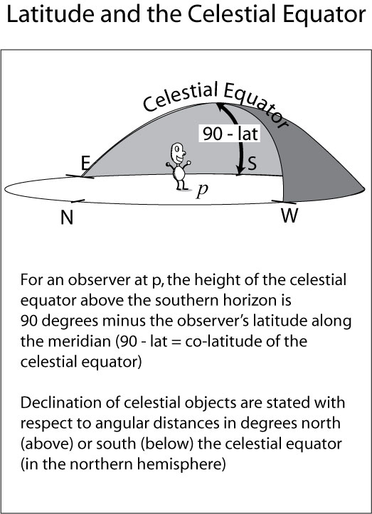
For an observer, the celestial equator is an arc across the southern sky
The celestial equator intersects the observer’s horizon at his/her due east point
It is highest at the point it crosses the observer’s meridian
It extends to and intersects the horizon at the observer’s due west point
At the meridian, the celestial equator has a height above the horizon equal to 90 degrees minus the observer’s latitude
Our GIS lab on the UAlbany campus has a latitude of 42 deg, 41 min, 14 sec N (42.6872 degrees)
Along this line of latitude, the celestial equator has a height of 90 – 42.6872 or 47.3128 degrees
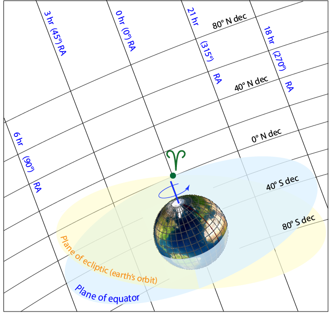
An object’s declination is its angle above the celestial equator (toward the projection of the N polar axis onto the sky) or below it (toward the S polar axis)
An object's right ascension is measured as an angle from the first point of Aries
The first point of Aries (symbolized as ) is the meridian passing through the point in the sky at the moment the center of the sun crosses the celestial equator from north to south (as seen from the surface of the earth)
When the center of the sun passes through this point, it marks the beginning of spring in the northern hemisphere
The zero-hour circle of right ascension corresponds to the direction of the vernal equinox (first point of Aries),
Each hour of right ascension corresponds to 15°
360° / 24 hours = 15° per hour
This sun simulator is a good model of the sun's apparent motions across the sky for any day and time over a year
Try setting the simulator to March 19 and run it at high speed to watch the sun declination circle (yellow) approach and eventually cross the celestial equator (blue)
The moment of crossing should occur sometime on March 21 although it's a little hard to tell exactly when it happens
I believe credit for this simulator goes to Kevin M. Lee of the Nebraska Astronomy Applet Project but attribution information is hard to find on this page
For us, the absolute location of the 0h circle is no more important than that of the prime meridian—both are arbitrary starting points
Every ‘fixed’ celestial object (as opposed to the planets or other objects with fast apparent motion relative to the earth) has a fixed declination and right ascension
The stars do not move with respect to the grid—they will always have the same coordinates
The sun, moon, and planets do change in both declination and right ascension over relatively short periods of time
Their positions are updated in almanacs for dates and times of day
Star positions do of course change over very long periods of time due to long period changes in the earth's rotation but that’s not important now
Because a sidereal day is 3 minutes and 55.909 seconds shorter than a solar day, stars will appear to rise and set 3 minutes and 55.909 seconds earlier each day
Just like our SVs
Celestial coordinates resemble latitude and longitude but do not rotate with the earth
Points on the SV orbital planes are fixed with respect to declination and right ascension (RA)
The orbits do precess but slow enough that it is practical to describe their orbits over periods of days with declination and RA
Using declination and right ascension to find an object in the sky
Tables of astronomical objects give their celestial coordinates
The beginning of spring is defined as the time at which the sun appears to cross above the celestial equator (declination 0) at right ascension 0 (the First Point of Aries)
Using the ephemeris, enter the approximate date for the first day of spring this year (the vernal equinox) and enter a time of day (0 hours, 0 minutes, and 0 seconds is midnight on that day)
The time of day is UTC using a 24 hour clock
UTC can be found by adding 5 hours to Eastern Standard Time or 4 hours to Eastern Daylight Time
For example, enter March 20, 2020, 0 hours, 0 minutes, 0 seconds and click the Get Ephemeris button
Now check the position of the sun at that time in declination and right ascension
It should be relatively close to 0 for each coordinate
Keep adjusting the date and time as necessary to get the declination and RA of the sun to exactly 0.
What date and time do they give for the beginning of spring in Eastern Daylight time?
The ephemeris gives the beginning of spring in EDT so subtract 4 hours from the almanac UTC value to get to Eastern Daylight time
How close is the time in the Almanac to the time that you entered on the ephemeris page?
A variation on sidereal time: Local sidereal time
So far, we have only considered a definition of sidereal time that applies to all earth locations simultaneously
Astronomers use a modification called local sidereal time that makes observing stars with known declination and right ascension coordinates easy
All observatories have sidereal clocks (dividing days up into the time it takes the earth to rotate 360°)
The local sidereal time at the observatory is set to the right ascension (hour angle) of the meridian crossing the center of the telescope's field of view at the moment—let's say 8 hours 30 minutes
The clock still measures a sidereal day—we're just resetting the current time
Since RA values are given in hour angles, an object with an RA one hour greater than initial meridian will pass across the telescope's meridian in one hour.
So, if a star has an RA of 9 hours, 30 minutes, it will cross the telescope's meridian 1 hour after we reset the local sidereal time