Celestial navigation is the practice of finding an earth position and plotting courses through observation of objects in the sky
The Geometry of Navigation
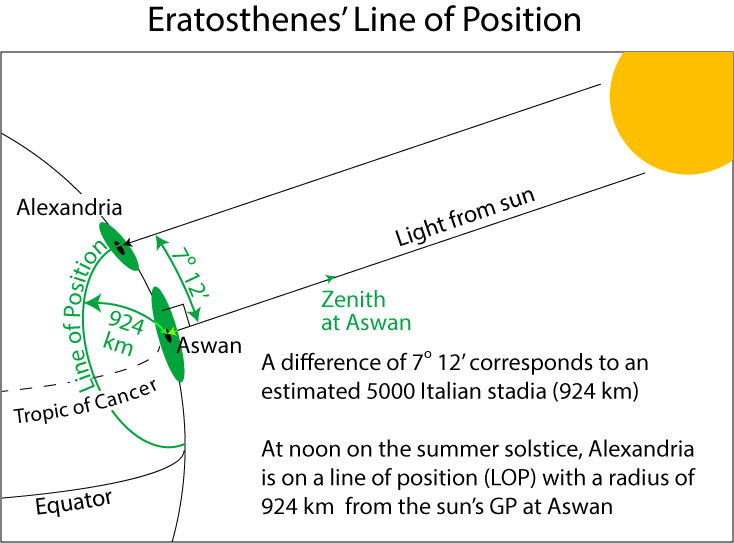
Eratosthenes used celestial observation to determine the circumference of the earth
Eratosthenes knew a couple things from observation:
The sun was directly overhead at Aswan, Egypt at noon on the summer solstice
Light rays emitted by the sun all appear to come from the same direction in the sky
This marks the geographical position (GP) of the sun at that day and time
The GP is the position, at a given time, at which the sun is directly overhead (at zenith)
So, at noon on the solstice (appx. June 21), the sun’s GP was the latitude and longitude at Aswan
At the same time, at a point in Alexandria (Eratosthenes’s location and almost on the same meridian (line of longitude) as Aswan), the sun was 82 degrees, 48 minutes above the horizon
Since the two locations are almost on the same meridian, most of their ground distance can be attributed to difference in latitude
Thus there is a 7 degree, 12 minutes difference between the latitude of Alexandria and Aswan (90 degrees – 82 degrees 48 minutes)
7 degrees, 12 minutes (7.2 degrees) is 1/50 of a circle (360 degrees)
Eratosthenes also knew the ground distance between the two locations
5000 Italian stadia (1 Italian stade is 184.8 m)
924 km in modern units
Since 7.2 degrees is 1/50 of the earth’s circumference and covers 924 km,
924 * 50 = 46,200 km (estimated circumference)
An approximately 15% overestimate of the currently accepted value of 40,075 km at the equator (not bad!)
In modern terms, Eratosthenes’s location in Alexandria was on a line of position (LOP) with an angular difference of 7 degrees, 12 minutes from the sun’s GP (over Aswan) at 12:00 noon on June 21.
You can use the following app to play with the Eratoshenes calculations
Drag a line of latitude to a new location to restart the simulation
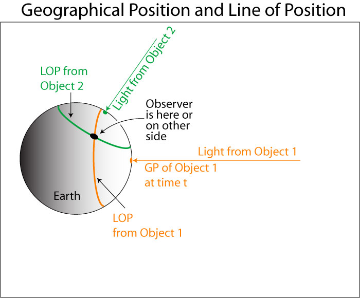
Eratosthenes calculated a point on a line of position
A line of position (LOP) is an arc of a small circle centered on the geographical position (GP) of an observed celestial object
Modern celestial navigation techniques find a position as the point of intersection of 2 or more lines of position (LOP)
The GP for a celestial object is the position on the earth over which the object appears directly overhead at a given time
First, you observe the altitude angle of the object above the horizon and subtract it from 90 to get the object's co-altitude
The altitude angle of an object is its height directly above the horizon measured in degrees
Then, using your time of observation, you find the GP of the object (in latitude and longitude) in your nautical almanac (see below)
The GP is the nadir point on the earth for the object at the given time
The nadir is the point directly underneath the object
Someone at this point and time would observe the object directly overhead
The radius of the LOP (in nautical miles) is the co-altitude of the object times 60
1 degree covers 60 nautical miles on the surface
A plot of this arc is called a sight reduction
The plot is usually a small arc section of the LOP at large scale
If you can plot 2 LOPs, you can locate your position on the earth
Finding the GP of an observed celestial object
You can find the GP for the sun and other objects at any time in the Nautical Almanac

 Harrison H4 chronometer, from